Shillong
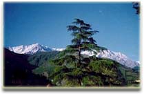 Shillong is the capital of Meghalaya at an altitude of 1, 496 mts above sea level and was carved out of Assam. the city stretches for about 6 km on an elevated tract. It is situated on a plateau bound on the north by the Umiam gorge, on the northwest by the great mass of the Diengiei Hills that rise up to a height of 1,823 meters (6077 ft.) above sea level, and on the northeast by the hills of the Assam valley. The Umshyrpi and the Umkhra rivers, which finally merge and form the Umiam River, water it. Shillong is at distance of 104 km from Guwahati, 295 km from Kaziranga, 578 km from Siliguri and 658 km from Darjeeling. The climate is hot and humid during summers. The monsoons arrive in June and it rains almost until the end of August. Shillong is quite cold during winters.
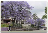
Shillong the capitol of Meghalaya which was planned by the British as a hill resort and remain summer retreat of the British, the beautifully kept golf course and several English country cottages testify to another influence besides the local one. Beautiful lakes and falls, hillside cottages, a large university, and the popular Bara Bazar are quaint aspects of this town. The place, the people and the climate all combine to create an atmosphere to make Shillong an ideal holiday resort throughout the year. Cherrapunjee, the wettest place on earth is only 56 kms away from Shillong.
Shillong was a small village until 1864, when it became the new civil station of the Khasi and Jaintia hills. It remained the summer capital of Eastern Bengal and Assam for many years. In 1874, on the formation of Assam as a Chief Commissioner's Province, it was chosen as the capital of the new administration. An earthquake destroyed the city in 1897, necessitating its complete rebuilding. In January 1972, Shillong became the capital of the newly formed state of Meghalaya.
MUST SEE:
Botanical Garden:
Ward Lake:
Museum:
Crinoline Falls:
Sweet Falls:
Shillong Peak: The Shillong Peak is at a distance of 10 kilometers from the Shillong city. The altitude of 1,965m makes it an ideal spot to feast the eyes with vistas of the spectacular Shillong. At the Shillong Peak the local deity Shyllong or Lei Shyllong is worship. The deity lends its name to the Shillong.
Elephanta Falls:
Iewduh Bara Bazar:
Beadon Falls:
Umian Lake:
Shillong Golf Course:
Polo Grounds:
NEAR BY DESTINATIONS:
Maphlang Sacred Grove 22 kilometers.
Cherrapunjee 54 kilometers
Nongkrem 13 kilometers
Jakrem 64 kilometers
Lum Nehru Park
BEST TIME TO VISIT: October to November and resumes from March to April.
THE WAY TO SHILLONG:
By Air:
Nearest airport to shillong is Guwahati-129 kms.
By Rail: Nearest Railhead is Guwahati- 103 kms.
By Road: Guwahati-103 kms, Calcutta-1184 kms, Kaziranga-294 km, Siliguri-578 kms, Manas-273 kms. Taxis also available at Guwahati for Shillong (4 hours).
National Highway number 40 an all-weather road connects Shillong with Guwahati. The State Transport buses and the private transport operators operate and offer services to the various places in Meghalaya and the neighboring states from Shillong. The bus stand is located in the heart of Shillong
Route: , Distance: .